How will extreme weather events likely impact the Morro Bay watershed and estuary?
Extreme weather events such as severe storms, flooding, extended periods of drought, and increased wildfire risk could have major impacts on humans, wildlife, and habitats in the watershed and estuary.
Floods, drought, heat waves, torrential rains — extreme weather events are becoming increasingly common around the globe. Changes in these types of weather events are not predictable, with expected shifts in the frequency and magnitude of the extremes. The Estuary Program works with partners to improve understanding of these potential changes and develop adaptations to protect both human infrastructure and natural habitats.
Extreme Rainfall Events
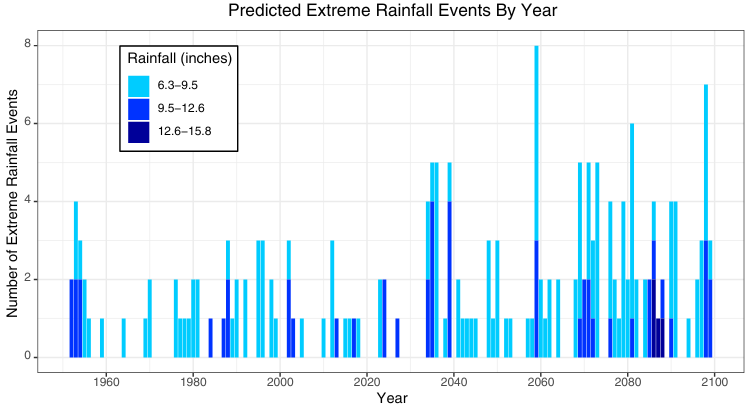
Extreme precipitation events are expected to increase in frequency throughout the rest of the century. An extreme precipitation event is a four-day period with exceptionally high rainfall totals compared to historical data. The colors in the graph indicate the projected inches of rainfall per year for a four-day event, and the height of each bar indicates the number of extreme rainfall events per year in the Morro Bay area.
Safeguarding Infrastructure
With intense rainfall comes an increased risk of flooding. Low-lying infrastructure and natural habitats can be vulnerable when waters rise. The extreme winter storms of 2023 highlighted the vulnerability of transportation corridors in the watershed when the community of Los Osos was temporarily cut off due to flooded roads. These roadways are central to community life, underscoring the need for analysis and the development of adaptations to protect them.
The San Luis Obispo Council of Governments (SLOCOG) launched a program with funding from Caltrans to develop solutions to improve car and bicycle transportation between Morro Bay and Los Osos and protect natural habitats. The project created an inventory of transportation infrastructure and habitats and developed a model to predict water movement and flow patterns. SLOCOG will create a summary of coastal hazards and vulnerability assessments to better understand risks in this area.
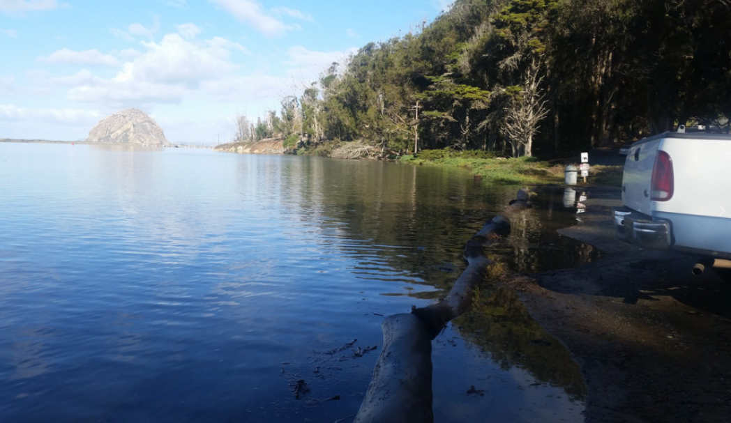
This is the parking area at Windy Cove (near Morro Bay State Park) during an extreme high tide. If sea levels rise to the higher end of the predicted range, portions of South Bay Boulevard and State Park Road near Windy Cove could face daily tidal flooding like this by 2060.
Protecting Habitats for the Future
The 400-acre tidal marsh, where Los Osos and Chorro Creeks enter the estuary, provides a unique habitat for wildlife and plants adapted to saltwater inundation from incoming tides. Rising sea levels and coastal flooding threaten this area as higher water levels may drown marsh plants and reduce the habitat available for wildlife. The Estuary Program has partnered with USGS to develop strategies to help preserve the marsh and transitional habitats for the wildlife that live there. This work helps identify potential ways to reduce damage to fragile ecosystems, such as providing upland space where the marsh could expand or adding sediment to raise marsh elevation.

USGS staff use surface elevation tables to measure elevation changes of the marsh surface. In general, the salt marsh is gaining in elevation as sediment is deposited from Chorro and Los Osos Creeks. But if the rate of sea level rise accelerates in the future, this sensitive marsh habitat may eventually transition into mudflats.
How Extreme Weather Events Take Shape
When predicting the future of extreme weather events, scientists are calling for both extended droughts and more severe storms. At first, the idea seems contradictory – how can we predict both more rain and less rain at the same time? According to Dr. Daniel Swain, renowned climate scientist, wildfire advisor, and founder of the popular Weather West blog, the key is the atmosphere’s ability to hold on to evaporated water.
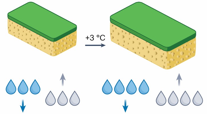
In a recent publication, Swain and fellow researchers explored the concept of “hydroclimate volatility,” or the rapid and intense swing between very dry and very wet conditions (Swain et al. 2025). The article outlined a simplified model in which the atmosphere is represented by a large sponge.
As the atmosphere warms, the capacity for it to hold more water vapor increases, therefore our hypothetical sponge becomes “thirstier.” Following the analogy, our thirsty sponge takes longer to become fully saturated with water and when it is wrung out, significantly more water is released all at once. In other words, longer droughts emerge because the atmosphere holds onto water vapor for longer periods of time and small rain events are less frequent. By the time the atmosphere has become saturated with water vapor and the time has finally come to release it, the resulting deluge can be fairly extreme and cause extensive flooding.
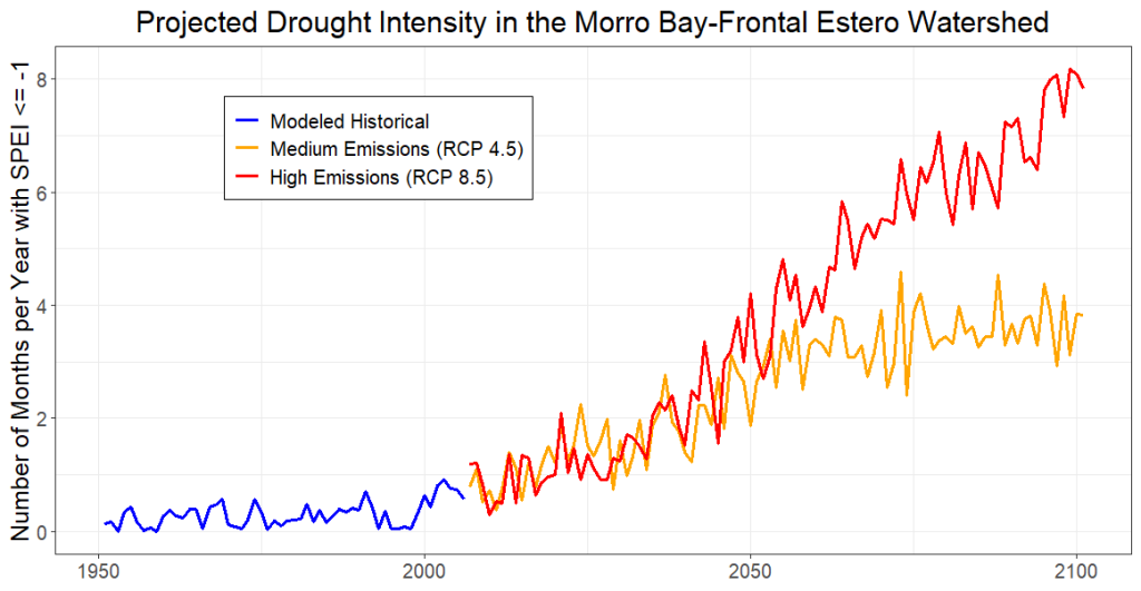
The Standardized Precipitation-Evapotranspiration Index (SPEI) is a metric of drought intensity, with negative values corresponding to more severe drought conditions. The number of months per year with an SPEI below negative one (drought level) is projected to increase under both medium and high emissions scenarios. Extended droughts mean drier vegetation, which in turn increases the likelihood of wildfires. Projected SPEI data for the Morro Bay-Frontal Estero Watershed comes from Cal-Adapt’s public data catalog (https://cmip5.cal-adapt.org/data/download/)
For more information on our weather and climate research, scan the QR code below.