Are the bay and creeks impacted by accelerated sedimentation?
Yes. Reducing accelerated sedimentation in the creeks is crucial for sensitive species like steelhead. Sedimentation impacts are more complex in the estuary, where sea level rise could outpace marsh elevation increases, resulting in large shifts in habitat.
The interaction between an estuary and the lands that surround it can be complex. In Morro Bay, sediment naturally washes from the uplands, down the creeks, and into the bay. However, human activities can greatly increase erosion, sending an excess of sediment into the bay.
The Estuary Program works with landowners in the watershed on projects to reduce erosion and trap sediment before it can degrade downstream habitats. Climate change and sea level rise pose a paradigm shift for tidal marsh habitats. While large sediment inputs can directly smother eelgrass and degrade habitats, climate models indicate that tidal marsh elevation gains will not keep pace with sea level rise. This could mean that higher water levels will swamp the high marsh habitat, converting it to mudflats by the end of the century.
Trapping Sediment in the Watershed
Nearly twenty years ago, the Estuary Program helped purchase and protect 580 acres at the foot of Hollister Peak, which later became known as the Chorro Creek Ecological Reserve and is now managed by the California Department of Fish and Wildlife. In 2019, the Estuary Program completed a 4.8-acre floodplain restoration project there to reduce the amount of sediment flowing to the estuary, improve creek water quality, support groundwater recharge, and create habitat for sensitive species like steelhead and red-legged frogs.
This video shows drone footage of the restoration work performed at Chorro Creek Ecological Reserve in 2019 and the resulting benefits in years after.
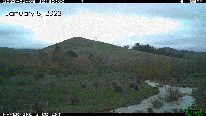
In January 2023, a series of storms hit San Luis Obispo County, leading to extremely high stream flows throughout the Morro Bay watershed. A rain gauge near the center of the Morro Bay watershed recorded over 9 inches of rainfall between January 1 and 24. The Chorro Creek Ecological Reserve performed as designed, giving the high flows room to spread out and slow down to reduce the amount of sediment carried to the bay. For more on the January 2023 storms, read our blog on the project.
The Estuary Program and our partners will continue to track the evolution of the project and the resulting ecological benefits. We monitor plant survival, floodplain activation, geomorphic monitoring of erosion and sedimentation, and overall stream health.
Monitoring Elevation Change in the Morro Bay Salt Marsh
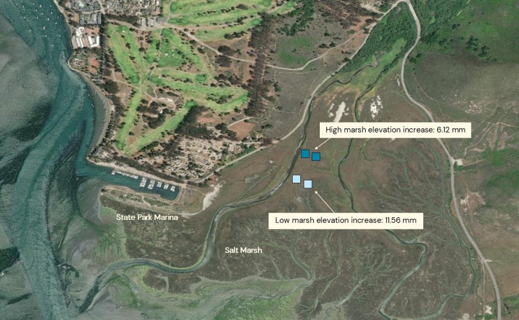
To better understand how the elevation of the Morro Bay salt marsh is changing over time, the U.S. Geological Survey (USGS) collects highly accurate measurements of marsh elevation change each year at four locations. Since the sites were established in 2013, the average cumulative elevation change at the sites is +8.84 mm, indicating that the salt marsh is increasing in elevation. However, with the projected rate of accelerated sea level rise, this marsh habitat will be more frequently inundated by the tides and could eventually convert to mudflats.
While the elevation of the Morro Bay salt marsh is currently keeping pace with rising seas, accelerated sea level rise continues to threaten salt marshes and other coastal areas around the globe. The Estuary Program and its many partners continue to monitor, model, and study these changes while developing projects to help protect these vulnerable areas.
How We Monitor Marsh Elevation Change
USGS has monitored salt marsh elevation in Morro Bay for nearly a decade using two primary methods: a surface elevation table (SET) and feldspar marker horizons. These methods are precise, non-destructive, and used worldwide.
Tracking Bay Elevation Change
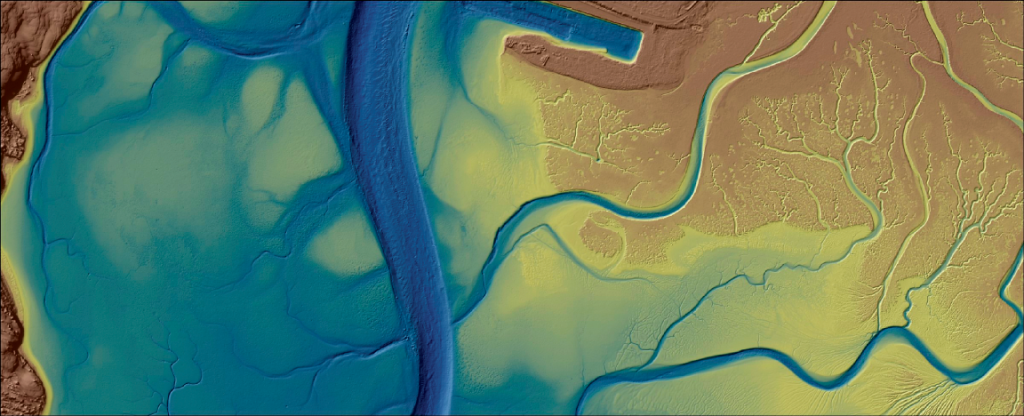
This is an underwater map of the bay floor. The blue colors represent the deeper depth of the channels near State Park Marina, and the brown shades represent higher elevations like the mud flats and salt marsh. The map came from the 2019 topobathymetric lidar (light detection and ranging) and sonar survey, which supported research into how eelgrass loss changed the bay floor. Using this survey and an older survey completed prior to the large eelgrass decline, Dr. Ryan Walter of Cal Poly’s Physics Department found that erosion occurred in over 90% of locations that had lost eelgrass, leading to the bay getting deeper in those locations. However, at the bay mouth where eelgrass beds were more stable, significantly less erosion occurred and the bay actually got slightly shallower.
More Data is on the Way
Analysis is underway on another lidar data set collected in summer 2022, and with the rebound in eelgrass since 2019, this information should provide insights into the relationship between eelgrass and erosion.
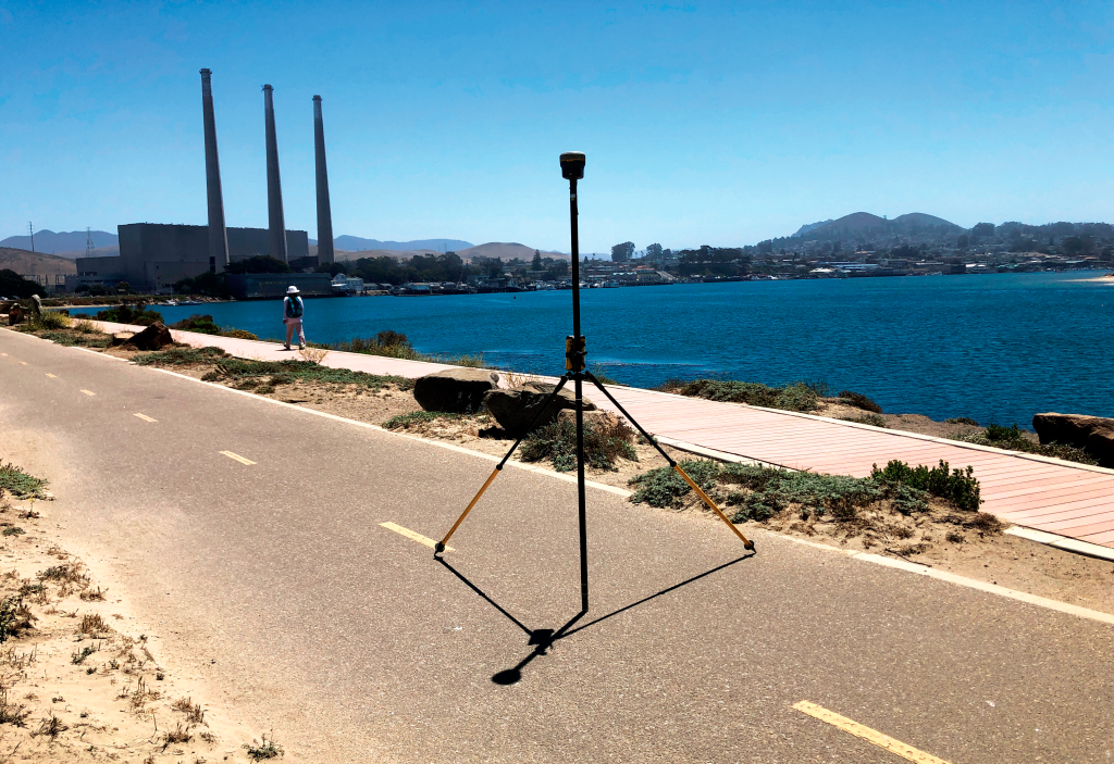
During a lidar survey, a plane flies over the bay at a low tide, transmitting a water-penetrating laser toward the water and exposed mudflats. A receiver on the plane detects the reflected light, which is then used to create a map of the bay-floor elevation. Part of the mapping effort involves field crews using survey-grade GPS (global positioning system) equipment (pictured above) to collect survey control points nearby. This information helps position the lidar data to create an accurate map.
The Estuary Program and USGS are partnering to use data such as the lidar surveys and tidal marsh sediment monitoring to model various future sea level rise scenarios and consider adaptation strategies to address habitat loss and coastal flooding.
Data Notes
Salt marsh elevation blog: https://www.mbnep.org/2022/12/02/field-updates-nov-2022-monitoring-salt-marsh-elevation-changes/
January 2023 storm blog: https://www.mbnep.org/2023/02/10/january-2023-field-updates-heavy-rainfall-and-high-flows/
USGS research on wetland resilience and vulnerability to sea level rise: https://www.science.org/doi/10.1126/sciadv.aao3270
2022 NOAA Topobathy Lidar DEM for Morro Bay, CA: https://www.fisheries.noaa.gov/inport/item/67998
Dr. Ryan Walter: Large-scale Erosion Driven by Intertidal Eelgrass Loss in an Estuarine Environment: https://digitalcommons.calpoly.edu/phy_fac/591/