Are the bay and creeks impacted by accelerated sedimentation?
Are the bay and creeks impacted by accelerated sedimentation?
Yes. Analysis shows that large storms events can greatly alter and degrade creek habitat for sensitive species like steelhead. Sedimentation impacts are more complex in the estuary, where sea level rise could outpace marsh elevation increases, resulting in large shifts in habitat.
The movement of sediment is a naturally occurring process in a watershed like Morro Bay. Erosion of stream banks and nearby lands can benefit habitat diversity by creating gravel bars that support steelhead or by forming sandbars that plants can colonize. However, excess erosion from events like intense rainfall after wildfire can have negative impacts on habitat by degrading water quality, clogging stream beds, and smothering eelgrass in the bay. Excess sedimentation in the watershed can have negative impacts on downstream habitats. Erosion of stream banks and nearby lands can degrade water quality and clog stream beds, which can harm wildlife. Sediment that makes its way to the estuary can smother eelgrass and other important habitat types.
The Estuary Program works with partners to manage erosion and other causes of sedimentation that threaten the health of the creeks and estuary. Another factor to consider with sediment is its relationship to shifts in sea level. Rising waters across the globe present an emerging challenge to tidal marsh habitats like those in the Morro Bay estuary that are vulnerable to inundation. Although these areas increase in elevation as sediment from the watershed washes down Chorro and Los Osos Creeks and settles there, rising seas will eventually outpace this natural process. If marsh areas are continually inundated with water, analysis indicates that the plant and animal communities present in the marsh today will be replaced by plants and animals that can survive in mudflats by the end of the century. While both habitats have value, this would represent a loss of the estuary’s unique and fragile tidal marsh ecosystem.
Monitoring Elevation Change in the Morro Bay Salt Marsh: 2013 to 2025
To track marsh elevation changes over time, the U.S. Geological Survey (USGS) monitors four sites in Morro Bay. This map shows the increase in marsh elevation at each site since 2013. Historical data indicates annual increases averaging 1.59 mm in the high marsh and 1.98 mm in the low marsh, enough to keep pace with the current rates of sea level rise. But if the rates of rising waters increase as they are projected to do, areas like Morro Bay’s marsh habitat will flood more often and could eventually transition to mudflats or open water. The Estuary Program is working with USGS to develop adaptation strategies to reduce habitat loss and coastal flood risks.
Estuary Program and USGS staff set up various types of monitoring stations to track sediment changes in the salt marsh.
Weathering the Storms: Chorro Creek Ecological Reserve
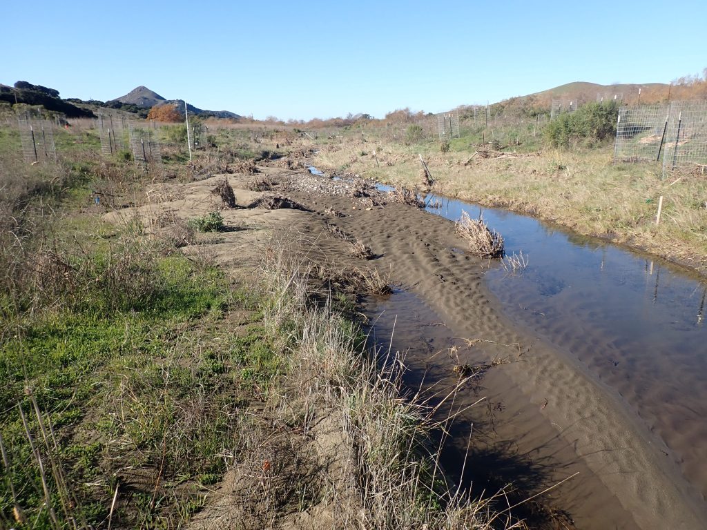
Over the past twenty years, the Estuary Program has supported land acquisition, protection, restoration, and monitoring at the Chorro Creek Ecological Reserve at the foot of Hollister Peak. The goals of our floodplain restoration efforts are to reduce sediment flowing to the estuary, support water quality for fish and other wildlife, and help recharge groundwater. During large storms in 2021 and 2022, the site operated as designed by trapping sediment and slowing the flow of water to reduce flooding.
The sediment deposited in the creek floodplain after large storms in 2022 indicates that the site operated as designed to capture excess sediment and prevent it from reaching the estuary.
The next challenges came during the major storms of 2023. The larger storms that year were estimated to be between 50-year (2% chance of occurring in any given year) to 100-year (1% annual chance) storms, and the area received nine inches of rain in the first three weeks of January. Water levels on Chorro Creek reached nearly 23 feet on January 9, the highest level recorded at this site since monitoring began in 1979.
This video documents the rising waters at the project site from late December 2022 to early January 2023.
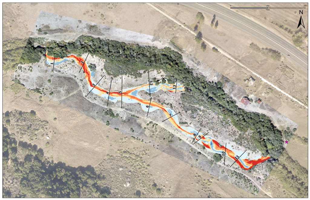
This aerial image of the Chorro Creek Ecological Reserve shows the creek channel and surrounding floodplain overlaid with elevation changes measured since 2021. The shades of orange and red denote areas where the elevation dropped, primarily in the creek channel where it was eroded by heavy storm flows. The shades of blue show where elevation increased. This was primarily in the floodplain areas where the flows spread out and slowed, leaving the sediment behind rather carrying it down to the estuary. Figure courtesy of WRA, Inc.
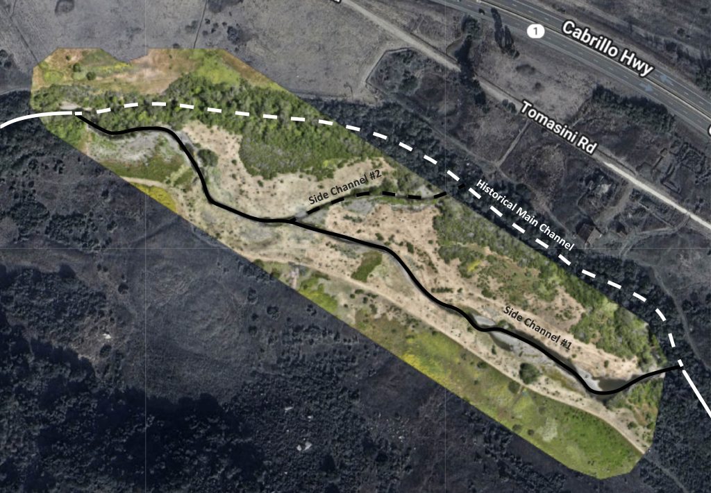
The high flows in January 2023 led to channel avulsion, where the water left the historical main channel (denoted with white lines) and instead moved through the floodplain area via the two side channels (represented with black lines). The site operated as designed, as this redistribution of flow helped slow down fast-moving waters and likely reduced erosion. Side Channel #1 (solid black line) now primarily serves as the main channel, with little to no flow in the historical main channel (white dashed line) or Side Channel #2 (black dashed line). Aerial image courtesy of Kevin Cooper.
Post-storm assessments of the site indicate that changes to channels in some restored areas could potentially impede the passage of fish through the creek. The site will require adaptive management to address areas of erosion, improve site stability, and ensure effective sediment trapping and habitat quality.
Tracking Changes in Our Creeks
To better understand creek health, we are interested in how streams change over time. One of the tools we use is cross sectional profiling, which involves surveying the shape of a creek channel. The cross-sectional profiles are permanent sites marked by metal rods called rebar benchmarks placed on opposite banks of the creek. These benchmarks allow us to return to the same locations to measure the shape and depth of the stream.
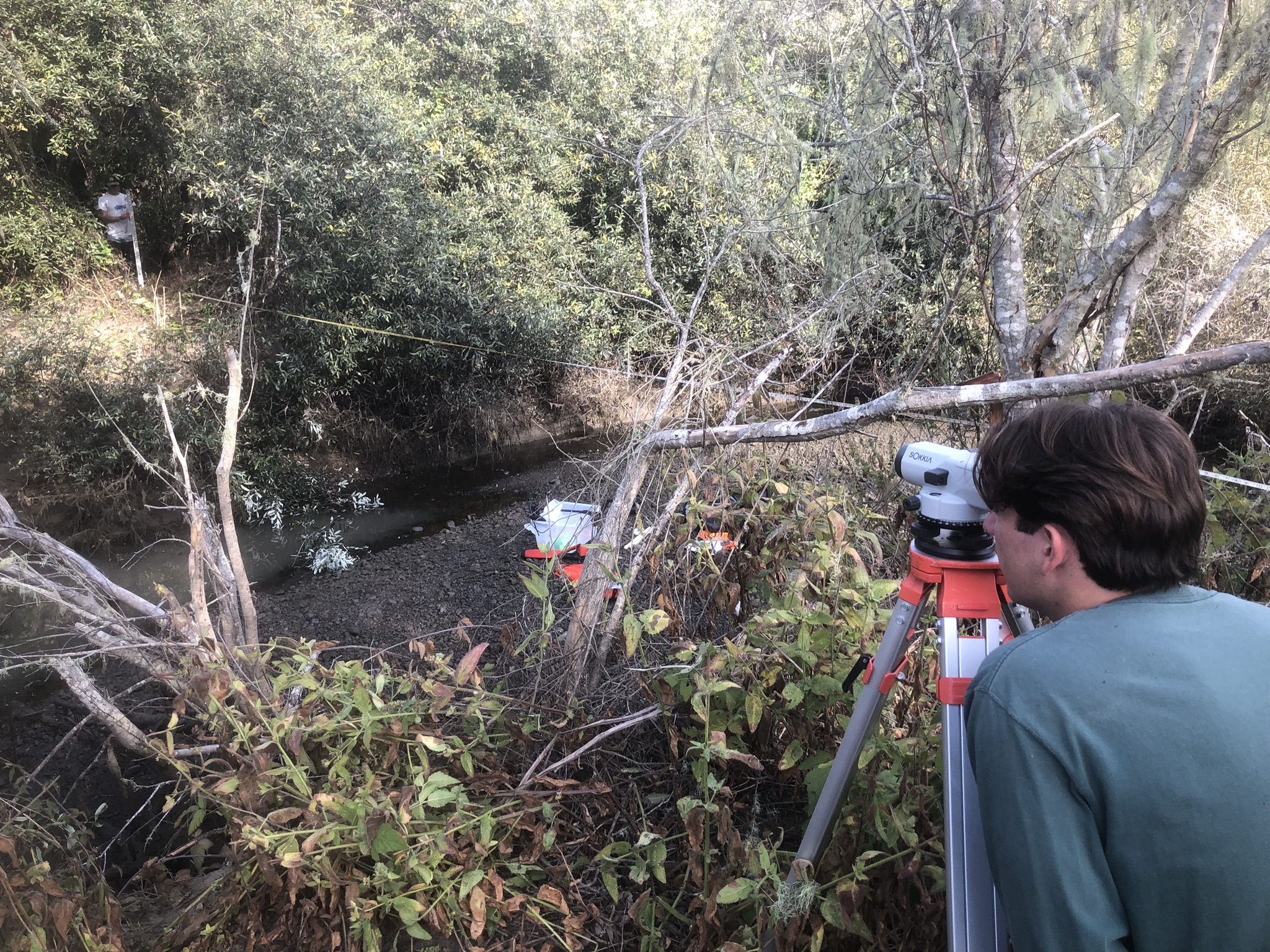
Students from Cal Poly supported our most recent cross-sectional profile monitoring effort, pictured here on Chorro Creek. The work involves using basic surveying equipment like an auto level and tripod to measure slope.
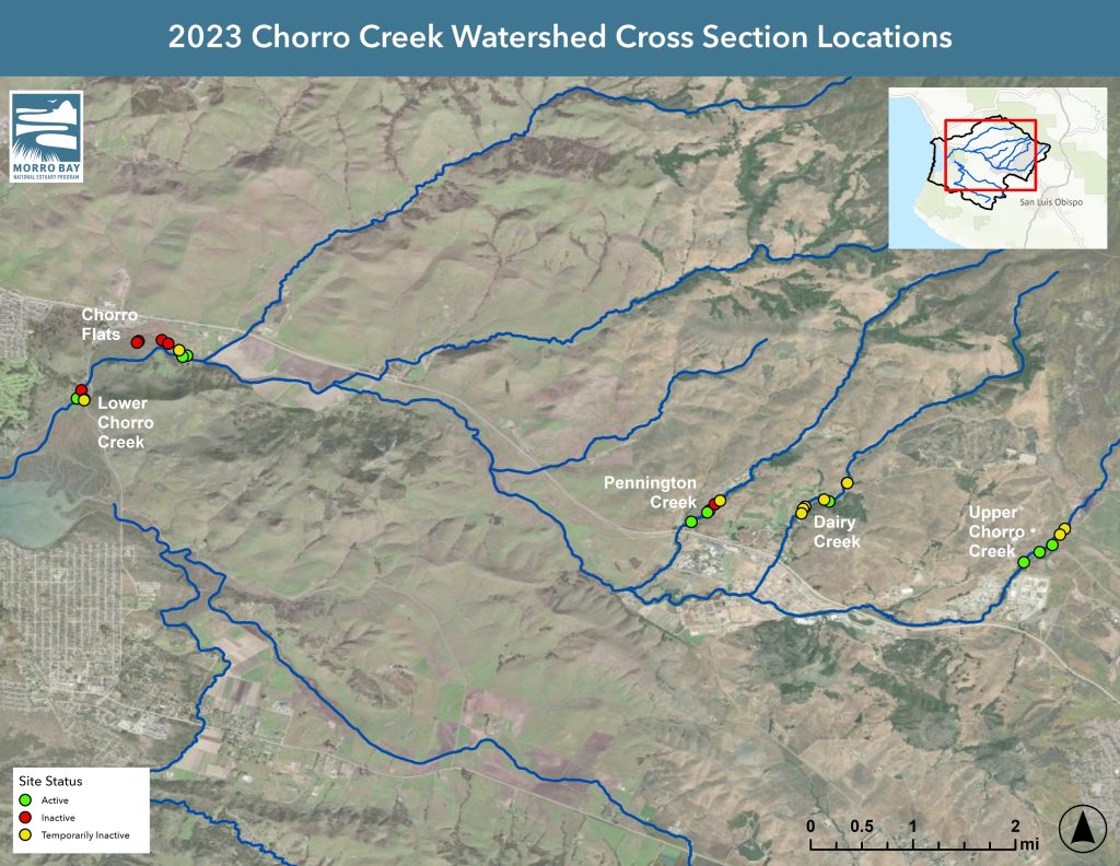
In 2023, the Estuary Program used maps, GPS units, and metal detectors to try to relocate 28 historic cross section sites for surveying. Of these, ten sites had two historic benchmarks present and were successfully surveyed. The remainder could not be surveyed due to lost benchmarks. These benchmarks were established in the 1990s and early 2000s by the EPA’s National Monitoring Program, the Coastal San Luis Resource Conservation District, and UC Berkeley.
The map shows the locations of the cross-section sites and the status of each. Active monitoring sites are shown in green, inactive sites in red, and temporarily inactive or inaccessible sites in yellow.
The survey results indicated a wide range of conditions, with some sites showing evidence of aggradation (where sediment builds up and raises the creek’s elevation) and others showing signs of erosion (where the channel becomes wider or deeper over time).
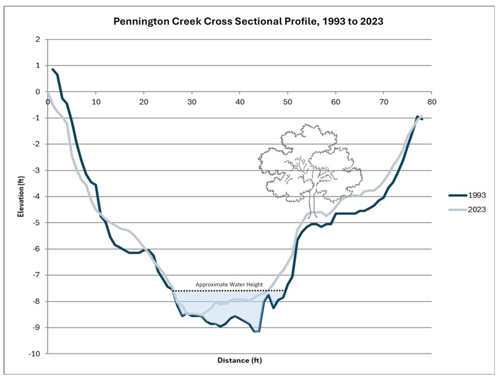
Although conditions throughout the watershed were variable, one long-term monitoring site on Pennington Creek stood out as more stable than others in the watershed. Between 1993 and 2023, the shape of the channel changed only slightly, with some sediment built up near the center and outer edges of the creek. This long-term stability indicates that the channel is in a healthy state that could provide more consistent habitats for the aquatic plants and animals that rely on them.
The graph above shows the cross section of a monitoring site on Pennington Creek. The dark blue line shows the bank location in 1993, and the gray line shows conditions in 2023. The data shows very little change in the creek during this thirty-year period, indicating a stable site. The dotted line shows the approximate water level when the site was monitored.
Data Notes
The sediment elevation table data was collected and analyzed by the U.S. Geological Survey from 2013 to 2025. Analysis of storm impacts on Chorro Creek Ecological Reserve were conducted by WRA, Inc. The map uses the NAVD 88 vertical datum.