Yes, the amount of eelgrass in the bay has increased rapidly over the last few years, with acreage surpassing pre-decline levels.
Eelgrass Status in the Estuary
Indicator Symbol: Very Good/Good
Hover symbol for indicator information
Eelgrass is a flowering plant that serves many important functions in an estuary. Its roots help hold bay sediments in place, which reduces erosion and keeps the waters clear. Eelgrass sequesters carbon, which keeps it out of the atmosphere and helps mitigate the effects of climate change. As a photosynthesizing plant, eelgrass also puts oxygen into the water to support other aquatic life. The plant’s floating blades form a sort of underwater forest that provides shelter and a place to find food for a wide variety of wildlife.
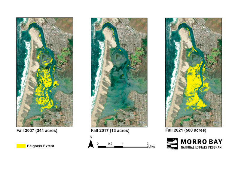
The Estuary Program has led efforts to map eelgrass for the past twenty years. The 2007 map indicated 344 acres of eelgrass. Over the next decade, eelgrass experienced a precipitous decline to only 13 acres. Since 2017, mapping has indicated an eelgrass recovery, with 500 acres mapped in 2021. Although the reasons for the decline and rapid recovery are not fully understood, a combination of factors such as water quality and elevation change likely played a role. Restoration efforts have also bolstered the recent recovery.
Eelgrass Acreage: 2007, 2017, and 2021
Eelgrass acreage (represented in yellow) declined from 2007 when 344 acres were mapped. In 2017, small patches of eelgrass appeared in the mid and back bay, which were the areas with the most eelgrass loss. Acreage has been increasing since 2017, with the 2021 map indicating 500 acres. Although some changes in the mapping methods occurred over time, the strong eelgrass recovery is welcome news to the Estuary Program and the community.
Eelgrass: Shaping the Ecosystem
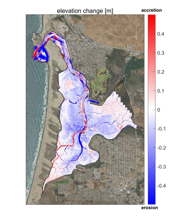
Seagrasses, such as eelgrass, are ecosystem engineers that beneficially shape the biological, chemical, and physical environment around them and sustain themselves through these processes. One example of this is the seagrass-sediment-light relationship. Eelgrass reduces tidal velocity and wave energy, resulting in sediment deposition and retention near the eelgrass beds. The eelgrass stabilizes the sediment, which helps keep the waters clear and allows more light to reach the bay floor. This in turn supports eelgrass photosynthesis and growth. The opposite happens when eelgrass abundance declines. Currents and wave energy near the beds increase, leading to sediment suspension and erosion. The free-floating sediment clouds the waters and reduces eelgrass’s ability to photosynthesize, ultimately affecting its survival and growth. When eelgrass is lost, the increased erosion and reduced water clarity can lead to an unvegetated state which inhibits future eelgrass growth.
In recent years, scientists have witnessed this cycle in Morro Bay. Large areas of the estuary where eelgrass disappeared during the decline eroded and became deeper. Areas where eelgrass beds remained stable are shallower by comparison.
This map shows the change in elevation in the bay from 2010 to 2019. Areas colored blue indicate locations that experienced erosion (became deeper) in that time period, while areas in red are those that became shallower. Analysis indicates that erosion occurred in over 90% of the locations that had lost eelgrass. At the bay mouth where eelgrass beds were more stable, significantly less erosion occurred and the bay actually got slightly shallower. Figure courtesy of Dr. Ryan Walter.
Eelgrass Mapping: Behind the Scenes
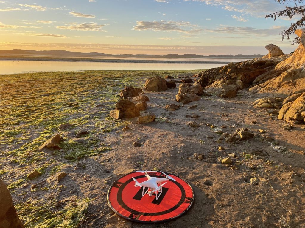
The DJI Phantom 4 Pro drone used by Cal Poly to map eelgrass awaits takeoff from Windy Cove. Photo courtesy of Cal Poly drone pilot, Ian Robbins.
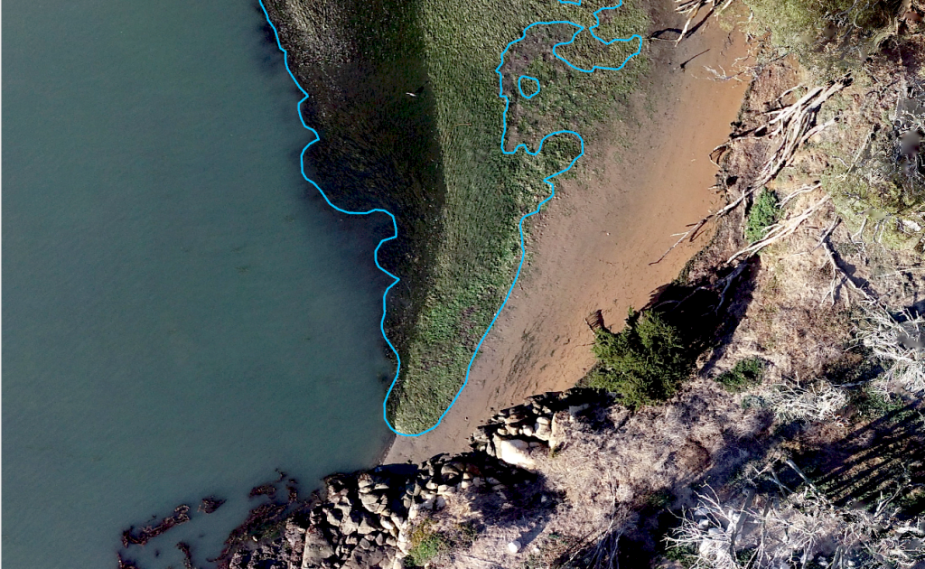
The Estuary Program started mapping eelgrass in 2002, building upon previous efforts that date back to the 1960’s. The mapping methods have changed over time along with advances in technology. Currently, the map is created in partnership with Cal Poly using high-resolution imagery captured by drone. The drone is programmed to fly a pre-determined path, allowing it to fly in precise lines across the bay and ensuring its camera records every square meter. After the drone has completed its flight, the photos are stitched together into one large, continuous map. Technicians use software to pick out patches of eelgrass, which are then added up to calculate the total acreage of eelgrass and produce the final bay-wide eelgrass map.
This picture shows how the outlines of eelgrass beds are traced over the high-resolution drone imagery in order to calculate an accurate acreage. For more detail on the eelgrass mapping process, read our blog post on the effort.
Eelgrass Restoration
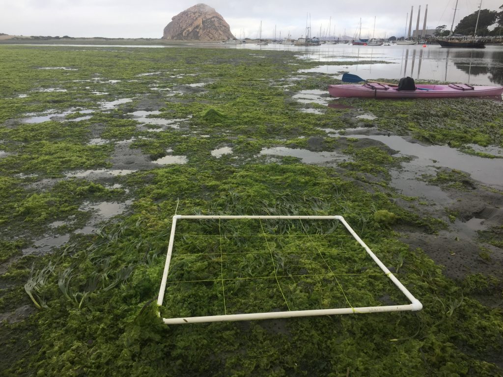
During the decline, eelgrass was harvested from healthy beds and transplanted in barren sites using multiple methods. To transplant eelgrass within one-meter plots, eelgrass rhizomes were secured in the sediment with garden stakes. Each one-meter plot contained 72 plants. The plots were marked with a piece of PVC so they could be revisited and assessed for growth in the following months.
One of three eelgrass restoration plots at a site near Bayshore Bluffs Park depicted during the initial planting (left) and six months post-planting (right). The plots at this location expanded by 180% in the six months following transplanting.
Eelgrass was also planted using rebar and bamboo pieces as anchors. This photo depicts the preparation of a bamboo anchor before planting, with 25 rhizomes secured to a three-foot piece of bamboo.
This photo shows how the bamboo was then anchored to the sediment with garden stakes and marked with a vertical piece of PVC so it can be revisited.
Faced with a large-scale eelgrass decline, the Estuary Program led restoration efforts from 2017 to 2021 with partners including Cal Poly, Tenera Environmental, Inc., and many volunteers. Over the last five years, nearly 15,000 plants were harvested from healthy eelgrass beds and transplanted at 39 sites in both intertidal and subtidal areas. With 500 acres of eelgrass mapped in 2021, the Estuary Program has ended restoration efforts and will continue to monitor the health of existing eelgrass beds and track large-scale changes in acreage over time.
Eelgrass Monitoring: Behind the Scenes
Estuary Program staff and Watershed Stewards Program volunteers set up a transect at Coleman Beach to monitor eelgrass density during winter Permanent Transect monitoring. This project is conducted yearly and includes six sites throughout the estuary.
Photos taken during eelgrass monitoring aid in tracking changes over time and have captured the incredible resurgence of eelgrass beds since the decline. These photos show how a monitoring site near State Park Marina transformed from a barren mudflat in 2017 (left) to a vast eelgrass bed in 2021 (right).
This collage highlights some of the creatures spotted during monitoring that rely on eelgrass beds for habitat and survival. From top left to bottom right: a brittle star, kelp isopod, ring-spotted dorid, crab, sculpin, and an opalescent nudibranch.
Cal Poly Eelgrass Research Efforts
Microclimate Experiment
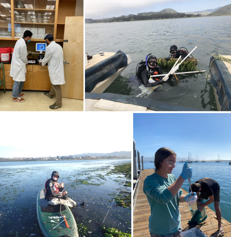
In July of 2021, Cal Poly professors Dr. Ryan Walter of the Physics Department and Dr. Emily Bockmon of the Chemistry Department deployed sensors both inside and outside of a large eelgrass bed to measure oceanographic conditions. Senior Research Scientist Ian Robbins, pictured here, collects a water sample next to the instruments. Photo courtesy of Dr. Ryan Walter.
The microclimate study sought to assess how eelgrass modifies water quality, focusing primarily on parameters associated with ocean acidification and hypoxia (low oxygen content). Results from the study show enhanced signs of biological activity in the eelgrass bed compared to outside the bed. In the morning, oxygen and pH reach a minimum due to respiration, and then climb to a peak in the afternoon when photosynthesis dominates. These results highlight how eelgrass can modify the local environment and create microclimates, which are important for the health of the eelgrass and the organisms that rely on it. The figure above depicts the two deployment locations, as well as the sensor arrays used for the study.
Monitoring Our Bay's Waters
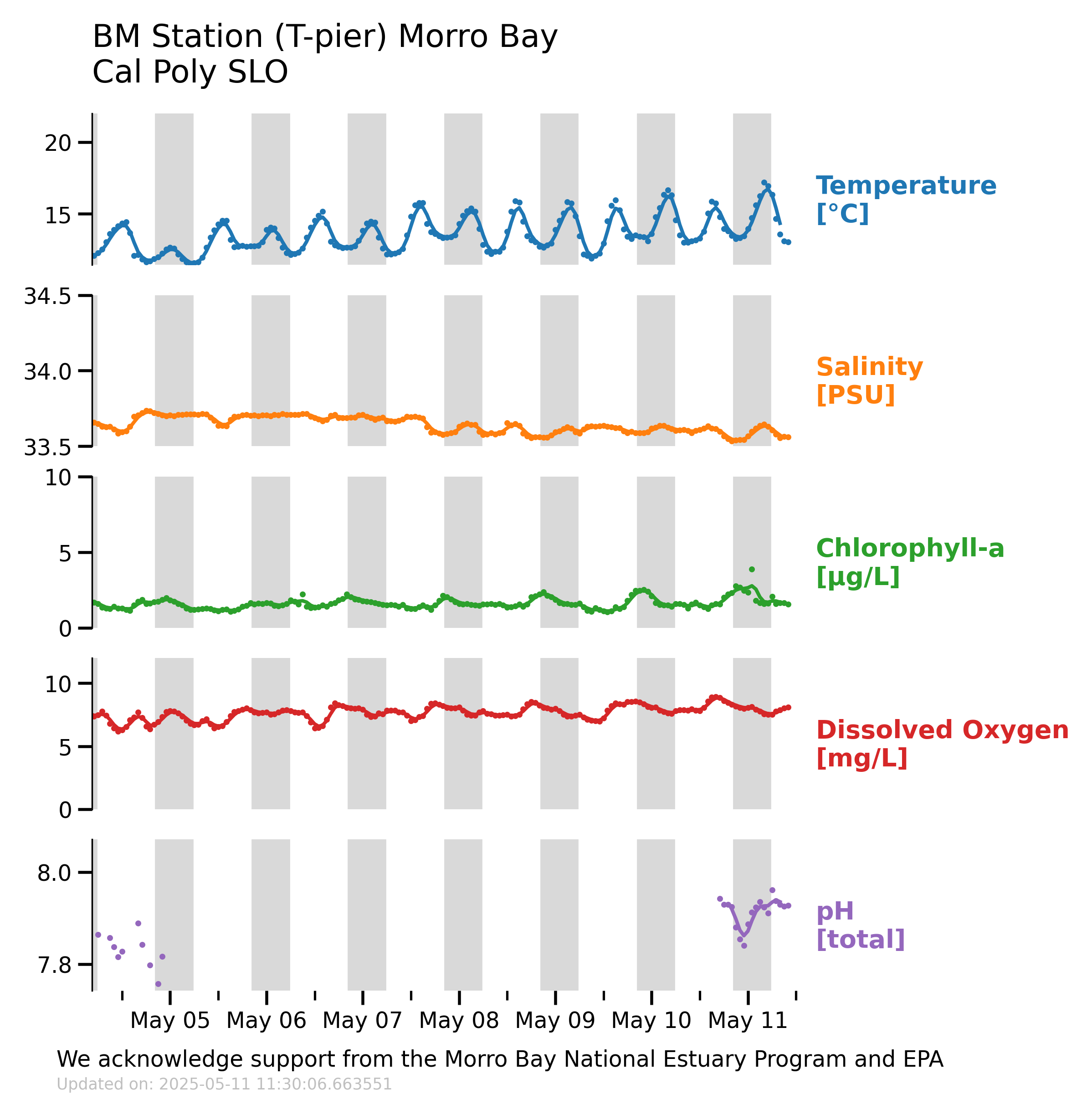
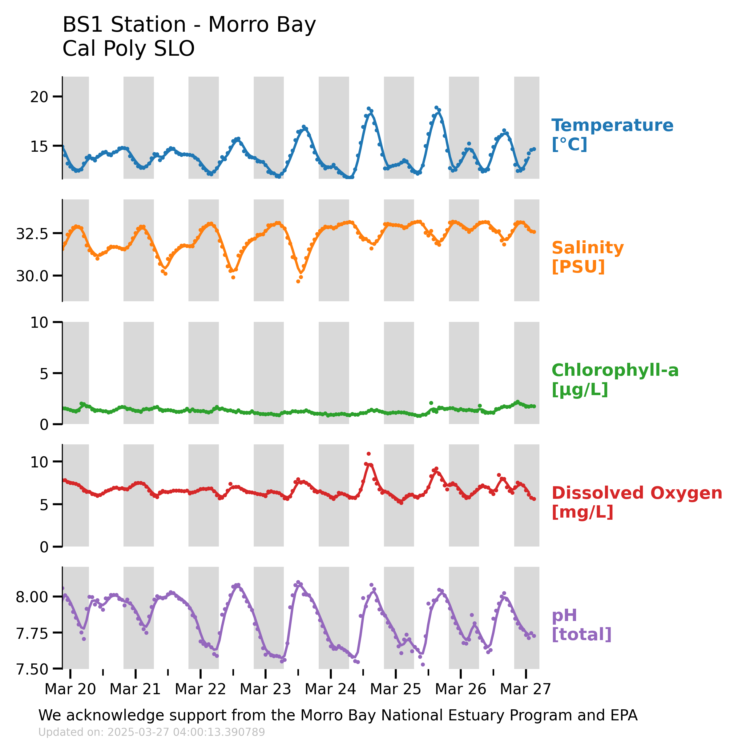
The Central and Northern California Ocean Observing System (CeNCOOS) is a federal program that established a network of buoys along our coast to collect water quality data. The Estuary Program provided funding to help support two solar-powered water quality stations in Morro Bay – one at the T-pier near the bay mouth and one in the back bay near the oyster farms. Cal Poly operates and maintains these stations. The sensors at both stations show near-real time water quality measurements, including data for conductivity, salinity, temperature, dissolved oxygen, chlorophyll, turbidity, and pH. Both stations contain cellular modems to transfer data back to Cal Poly campus servers.
This data is readily accessible via the CeNCOOS web portal and is used by the Estuary Program as well as researchers, educators, and the community to better track water quality in Morro Bay. The data supports efforts to better understand the impacts of climate change and shifts in the bay ecosystem.
Water quality monitoring sensors at the Morro Bay North T-pier measure temperature, salinity, chlorophyll, oxygen, and pH.
After extended time in the water, the sensors become encrusted with marine life which can interfere with their operation.
Senior Research Scientist Ian Robbins of Cal Poly conducts maintenance on the sensors.
The back bay sensor is located near the bay’s two commercial oyster farms. Cal Poly must conduct dives each month to keep the sensors operating properly. In addition to collecting water quality information, the site includes a meteorological station that measures parameters such as rainfall, wind speed, and air temperature.
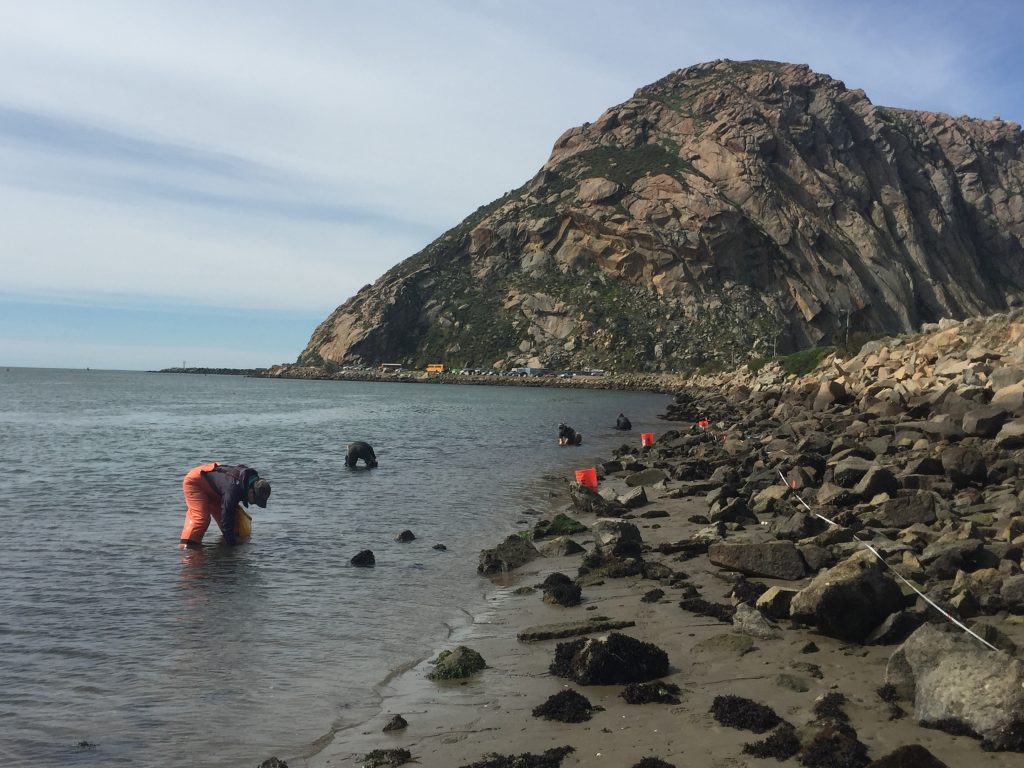
Drs. Silvio Favoreto and Laurie McConnico from Cuesta College have been studying the occurrence of the slime mold Labyrinthula spp. on eelgrass in Morro Bay since 2018. This project focuses on the distribution of the slime mold throughout the estuary and understanding its role in eelgrass wasting disease. This group of Cuesta students is sampling eelgrass blades from Coleman Beach.
The eelgrass blades are brought back to the lab where they are cultured on growth media to detect the presence of Labyrinthula spp. and assessed for health using a metric known as the Excess Green Index (EGI). Analysis has shown that low EGI scores are correlated with the occurrence of Labyrinthula spp. in the front bay and back bay, but this trend is not as strong in the midbay. The differences observed between locations are believed to be due to variability in the presence of stressors that weaken the eelgrass and make it susceptible to infection.
An additional component of the wasting disease project focused on using molecular biology techniques to determine the microbiome of eelgrass, which refers to the entire community of microorganisms that live on eelgrass blades. Analysis has shown that the microbiome of the front and back bay are similar, yet both differ from the midbay. It is believed that these differences may contribute to the lower incidence of Labyrinthula spp. in the midbay. Cuesta students, such as this molecular biology student, support the field and lab efforts. Photo courtesy of Dr. Silvio Favoreto.
Upcoming Project: Macroalgae Monitoring
Macroalgae can play a beneficial role in an estuary, providing food, habitat, and nutrient cycling in the bay. However, when excess macroalgae is present, it can have a variety of negative impacts on eelgrass and water quality. We have observed a recent increase in macroalgae, and eelgrass monitoring efforts indicate areas where macroalgae outcompeted eelgrass, as pictured above. A project is currently in development to assess algae coverage and biomass throughout the estuary in order to track these changes in abundance and their impact on eelgrass health.
Building Partnerships & Community Support for Eelgrass Recovery
From top left to bottom right: Cuesta students working on the eelgrass wasting disease project in the lab (photo courtesy of Dr. Silvio Favoreto), Tenera Environmental Inc. divers transplant subtidal eelgrass, a Watershed Stewards Program corps member helps with the fall eelgrass monitoring effort, and two of Dr. Emily Bockmon’s students analyze water samples for carbonate chemistry (photo courtesy of Dr. Emily Bockmon).
We are grateful for the many partners and community volunteers who joined us in eelgrass restoration and monitoring efforts. The work would not have been possible without this support! From 2017 to 2022, our volunteers spent nearly 500 hours getting wet and muddy while helping to harvest and plant eelgrass. Some people came out for a few hours, while others returned to help year after year. Cal Poly and California Sea Grant staff played a large role in developing initial experiments to determine the optimal restoration and monitoring methods. Tenera Environmental, Inc., a local consulting firm, also supported our eelgrass efforts and more recently led the majority of planting as COVID made it challenging to use volunteers.
A huge thank you to our community volunteers, including the AmeriCorps Watershed Stewards Program.
The Estuary Program has largely supported our eelgrass restoration work through grant programs such as the California Department of Fish and Wildlife Duck Stamp, Pacific Marine Estuarine Fish Habitat Partnership, Restore America’s Estuaries Coastal Watershed Grant, U.S. Fish & Wildlife Service Coastal Watershed Grant, and NOAA Sea Grant. The effort also benefited from donations from the Black Brant Group and from community members. We are grateful to the many funders who helped make this work possible.
For more information on the Estuary Program’s eelgrass work, visit our website.