The Morro Bay estuary is a popular recreation destination for tourists and residents. Clean water is essential for people to safely paddle, sail, kayak, and swim in the bay. Polluted water can contain things like bacteria, viruses, and protozoa that can make people ill. These pathogens can come from sources such as stormwater runoff, pet waste, agricultural operations, wildlife, treatment plant spills, and improperly operating septic tanks or boat-waste holding tanks.
To track bay bacteria concentrations each month, Estuary Program staff and volunteers collect and analyze water samples at bay shoreline sites where people often recreate.
How We Monitor Bacteria
The Estuary Program is partnering with Drs. Laurie McConnico and Silvio Favoreto of Cuesta College on a joint bacteria monitoring effort. Cuesta students, pictured here collecting a sample from the Tidelands dock, are responsible for collecting monthly samples from creek and bay shoreline sites.
After the collection is complete, students process the samples in Cuesta’s lab by diluting them and adding a chemical indicator. The water samples are then sealed in a tray and incubated overnight, allowing the bacteria to grow and trigger the chemical indicator.
Students return to the lab the following day to interpret the results. When the water samples contain bacteria, the chemical indicator causes the water to fluoresce. The trays pictured above are designed so that the number of individual wells with fluorescence indicate the concentration of bacteria in the sample. Trays with low numbers of fluorescent wells (left) have low concentrations of bacteria, and trays with many fluorescent wells (right) have higher bacteria concentrations. The final results are shared with partners such as landowners, agencies, and public health officials.
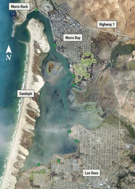
Bay Bacteria Status
This map shows the eight sites where the Estuary Program has monitored water quality monthly from 2005 through 2024. The green color of the circles indicates that bacteria levels are low and that these sites are typically safe for swimming. However, runoff from a storm can carry pollutants including bacteria into the bay, so public health officials typically recommend staying out of the water for 72 hours following a storm.
Other Bacteria Data
Another source of local bacteria data is Heal the Bay, an environmental nonprofit dedicated to making the Southern California coastal waters and watersheds safe, healthy, and clean.
Each year, Heal the Bay compiles a Beach Report Card that assigns an A to F letter grade to 500 California beaches using weekly bacteria results. The data comes from monitoring data from government agencies. Higher grades indicate a lower risk of illness to beachgoers.
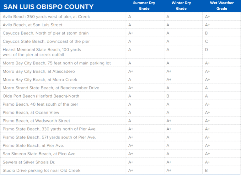
The following table shows the grades for San Luis Obispo County beaches for 2020 to 2021. The data was separated into three categories. Data are assigned to the Summer Dry season when beach usage tends to be higher. The Winter Dry season is November to March and only includes times without rain. The Wet Weather data includes times with rainfall throughout the year. This is because stormwater runoff can transport pollutants such as bacteria into our coastal waters, impacting our beaches. In 2020 to 2021, SLO County beaches received very high grades. Three of our local beaches, including Morro Bay City Beach, made it onto the Honor Roll list for scoring perfect grades year-round.
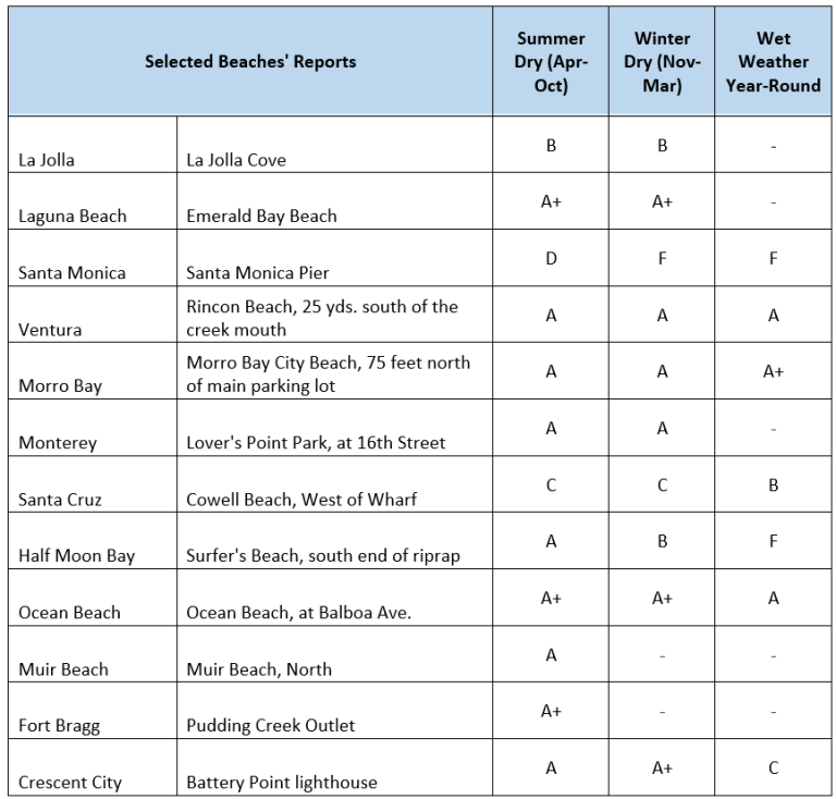
For comparison, here are results from some beaches throughout the state.
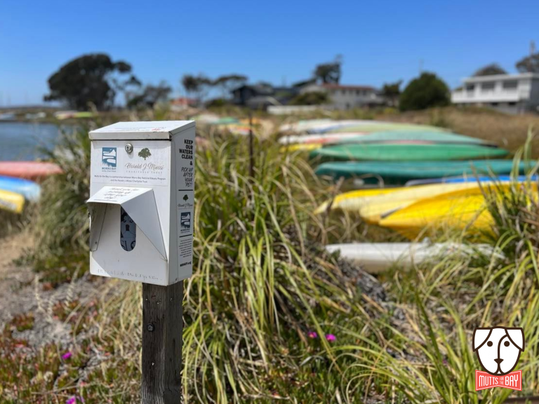
Waste bag dispensers, like the one pictured above at Cuesta Inlet, can be found throughout the watershed.
With approximately 5,500 dogs living in Morro Bay and Los Osos, an average of 19,000 pounds of dog poop is produced each week. If left on the ground, rain can carry bacteria from pet waste into local creeks and the bay, which can harm people and the environment.
The Estuary Program’s Mutts for the Bay program provides free pet waste bags at dispensers at parks and along public thoroughfares to make it easy for pet owners to pick up after their pets. We maintain 34 dispensers through the Morro Bay watershed in partnership with our dedicated community volunteers, private and business sponsors, and a generous grant from the Harold J. Miossi Charitable Trust. This grant has paid for the installation of four new dispensers and bags to help keep all of the dispensers stocked. The grant also supports our education and outreach efforts for students, community members, and visitors.
At the Estuary Program, we always get excited when the rainy season hits. While rainfall brings fresh water to our watershed, it can also cause pollutants like fertilizer and pet waste from our streets, parking lots, driveways, and yards to be flushed downstream. The Estuary Program supports projects that prevent pollutants from being carried into our bay during winter rains.
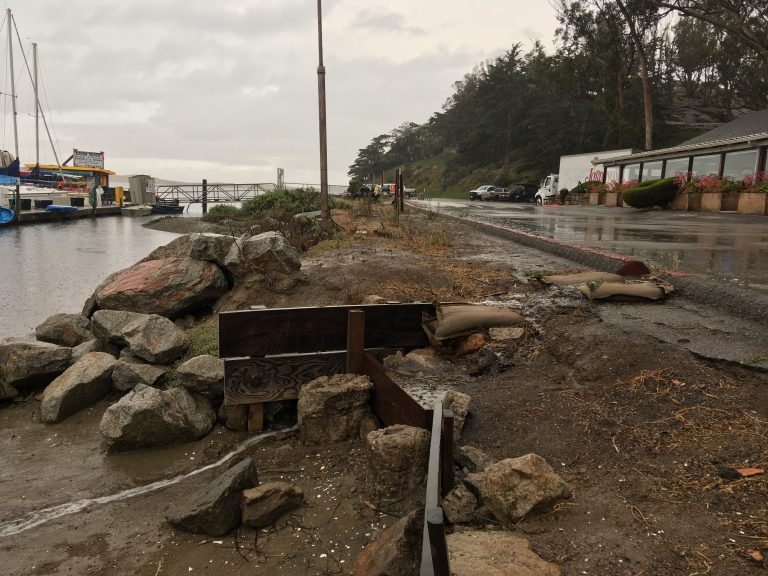
The State Park Marina is a popular spot for visitors and residents. The area has a large paved parking lot with cracked and broken pavement that was starting to show its age. The parking lot was sloped so that rainfall was funneled off the parking lot and directly into the bay without any treatment.
This photo shows the failing infrastructure that directed untreated storm runoff directly from the parking lot into the bay.
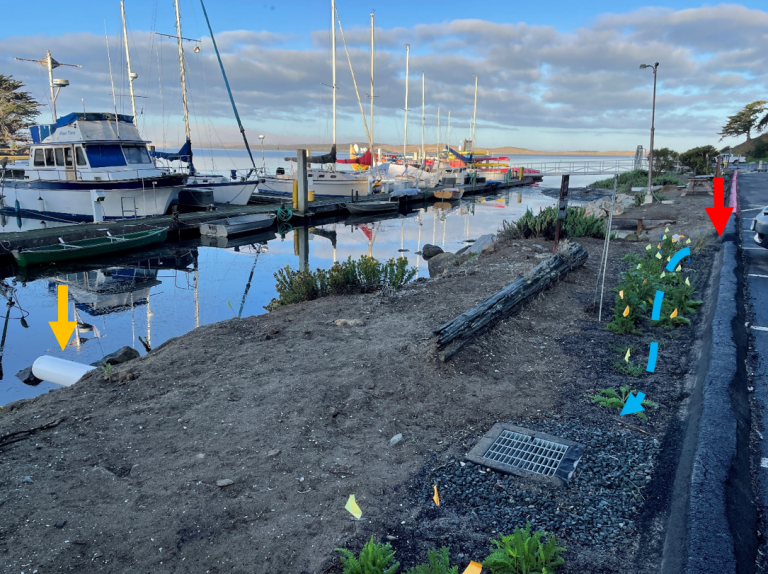
The Estuary Program worked with State Parks and the California Marine Sanctuary Foundation to obtain grant funding from the Ocean Protection Council to construct an improved parking lot and Best Management Practices (BMP) structures to treat the runoff. Construction was completed in spring 2022.
To treat the runoff before it enters the bay, structures called bioswales were installed along the bayside edge of the parking lot. This involved digging out a trench and filling it with filter fabric and gravel and soil of specific sizes to encourage water to sink into the trench. Plants were installed on the bioswales. Parking lot runoff is directed into the bioswales where the plants and the materials in the trench help filter out pollutants before the water is discharged into the bay.
As stormwater runs off the parking lot, it passes through cuts in the curb (indicated by the red arrow). The water is directed into the vegetated bioswale where it sinks in (indicated by the blue dotted line). The treated water is captured in a pipe along the bottom of the trench and is released into the bay (indicated by the orange arrow).
To assess how effectively the project is working, stormwater runoff was collected and analyzed from storms before and after project installation. Pre-project data indicated elevated bacteria and sediment concentrations reaching the bay. With construction complete, storm sampling is underway to assess the effectiveness of the project. Stay tuned for results!
For more information on the project, see our blog post.