At the Estuary Program, we always get excited when the rainy season hits. Rainfall brings freshwater to our watershed, refilling our streams and recharging our groundwater. Rainfall can also cause pollutants from our streets, parking lots, driveways, and yards to be flushed downstream. The Estuary Program monitors for these pollutants during large storms and supports projects that prevent pollutants from being carried into our bay during winter rains.
Protecting the Bay by Treating Stormwater Runoff
The State Park Marina boasts a restaurant, kayak rental, a public launch ramp, and boat slips and is a popular recreational spot for visitors and residents. To support these activities, the area also has a large paved parking lot. This lot was starting to show its age, with cracked and broken pavement. Beyond that, the parking lot was sloped so that during storms, rainfall was funneled off the parking lot and directly into the bay without any treatment.
Best Management Practices
The Estuary Program worked with State Parks and the California Marine Sanctuary Foundation to obtain grant funding from the Ocean Protection Council to design and construct an improved parking lot and Best Management Practices (BMP) structures to treat the runoff. Construction was completed in the spring of 2022. The project also involved monitoring the runoff during storms before and after the project installation to track the changes in the water quality.
Stormwater Treatment Systems
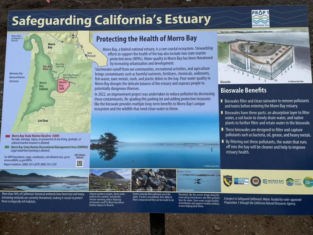
To treat the runoff before it enters the bay, structures called bioswales were installed. This involved digging out a trench and filling it with filter fabric and gravel and soil of specific sizes to encourage water to sink into the trench. Plants were installed on the bioswales. Parking lot runoff is directed into the bioswales where the plants and the materials in the trench help filter out pollutants before the water is collected in a perforated pipe and discharged into the bay. These bioswales were constructed between the edge of the parking lot and the bay.
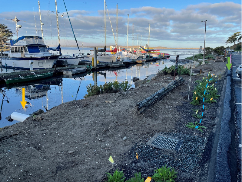
The project also included a sediment trap structure. Water from a portion of the parking lot is directed into the trap where the water can sink into the earth rather than running into the bay. The water collects in a perforated pipe and is discharged into the bay, leaving sediment behind in the basin. Also as part of the project, the cracked parking lot was regraded and repaved.
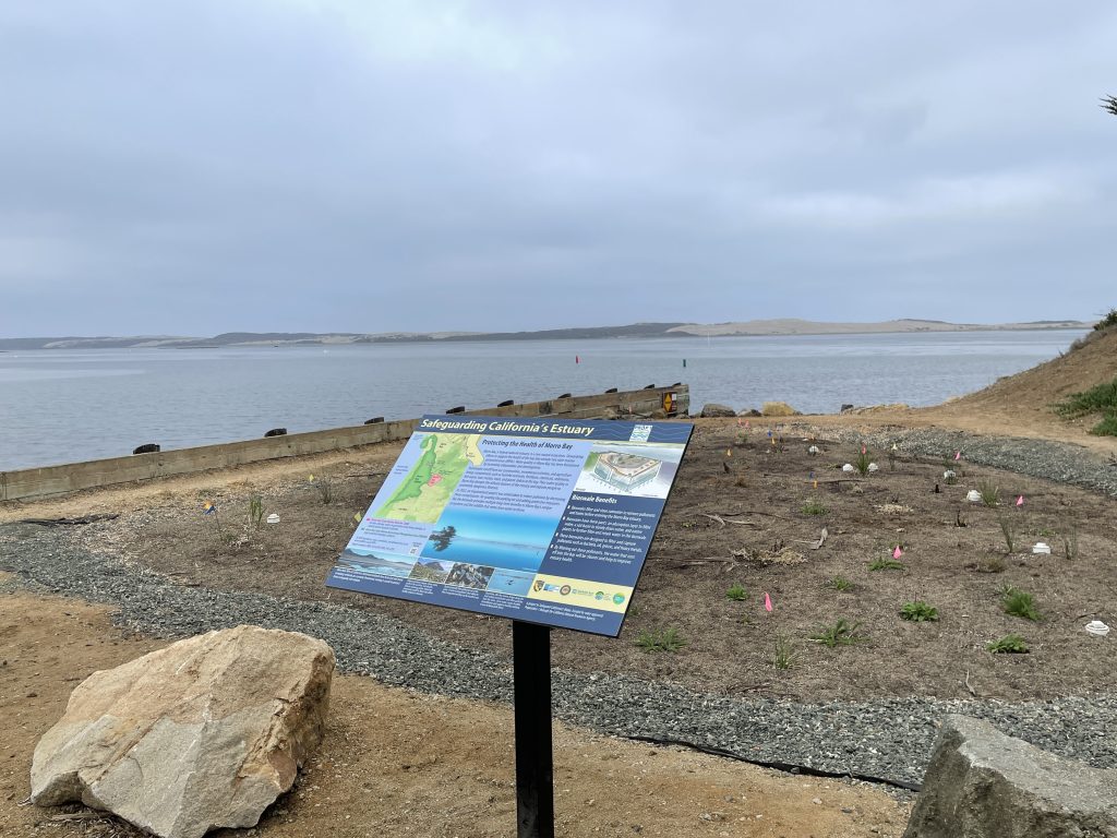
A component of the project was design and installation of a sign explaining how the project works to help protect bay water quality.
Testing the Waters
To assess how effectively the project is treating the runoff before it is released into the bay, stormwater runoff was collected and analyzed from storms before and after project installation. Pre-project data indicated elevated bacteria and sediment concentrations reaching the bay. With construction complete, storms in early November and early December 2022 were sampled. We plan on sampling one additional storm in early 2023, and then data will be available for comparison to pre-project data. Stay tuned for results!
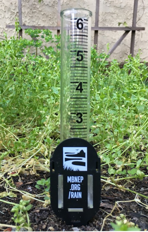
How to Track the Rain at Home
The Morro Bay Rain Gauge Network relies on local community members to collect rainfall data from their yards, businesses, schools, and offices. Volunteers can upload their rainfall results on our website, providing a hyperlocal community-oriented dataset.
If you are located in one of the areas labeled in the map below, we invite you to participate in our rain gauge network! These locations include Morro Bay, Cayucos, Los Osos, and San Luis Obispo.
Interested? Here’s how to join:
- Schedule a time to pick up your free rain gauge from the Estuary Program office. Or, use a rain gauge that you already have at home.
- Install your rain gauge in an open area away from overhangs, gutters, and downspouts.
- Any time it rains, record how much rain collects in your gauge. It is best to do this once a day during multi-day storms.
- Visit MBNEP.org/rain and scroll down to the data entry form. Enter your email address, choose your date and your watershed section (see the map above), and enter your rainfall total. We recommend checking your rain gauge at the same time each day and entering data for every day that you receive measurable precipitation.
- Watch your new data pop up in the Rain Gauge Network table. It will be averaged with other Rain Gauge Network stations in your watershed section, but you’ll also get to see data just for your rain gauge station displayed on the screen.
Help us protect and restore the Morro Bay estuary!
- Donate to the Estuary Program today and support our work in the field, the lab, and beyond.
The Estuary Program is a 501(c)3 nonprofit. We depend on funding from grants and generous donors to continue our work. - Support us by purchasing estuary-themed gear from ESTERO. This locally owned and operated company donates 20% of proceeds from its Estuary clothing line and 100% of Estuary decal proceeds to the Estuary Program. Thank you, ESTERO!
- Purchase items from the Estuary Program’s store on Zazzle. Zazzle prints and ships your items, and the Estuary Program receives 10% of the proceeds. Choose from mugs, hats, t-shirts, and even fanny packs (they’re back!) with our fun Estuary Octopus design, our classic Estuary Program logo, or our Mutts for the Bay logo.
Thank you for helping our beautiful, bountiful, biodiverse bay!