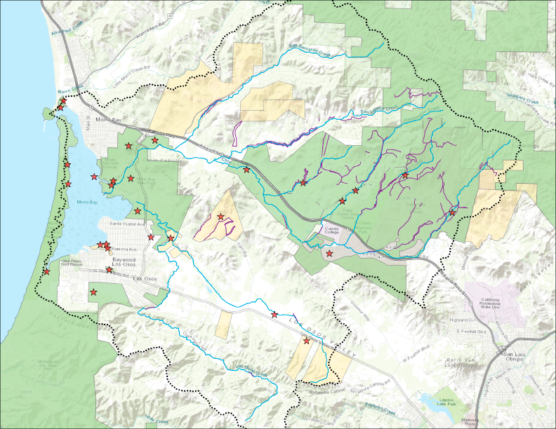
Are important natural areas being protected, enhanced, and restored?
Yes, more than 5,400 acres have been protected and thirty projects have been completed to improve natural areas and water quality.
The Estuary Program and our partners work to protect, restore, and enhance habitat in the estuary and the lands that surround it. These efforts help to maintain open space, conserve water, prevent pollution, and maintain healthy habitats for wildlife and for people.
Morro Bay Watershed Habitat Protected, Enhanced, and Restored
Healthy Wetlands Support Water Quality and Wildlife
Wetlands help control flooding, reduce erosion, improve water quality, and provide wildlife habitat. In the past, landowners often saw these areas as wasted space and would levee creeks and drain wetlands to maximize the available land. These practices disconnect the creeks and wetlands from the surrounding floodplain, removing their ability to provide these important ecosystem services.
The Coastal San Luis Resource Conservation District (CSLRCD) is an Estuary Program partner organization that works to protect and restore habitat. They led a multi-year effort to restore floodplain on Warden Creek near the confluence with Los Osos Creek. The project returns the property, including its wetland, to conditions that support wildlife and natural functions.
Native Plants Support Biodiversity
The Morro Bay watershed is one of the most botanically diverse regions in California. Many communities and species of plants have evolved as a result of active geologic change that can be traced back to the ice ages. Many plant communities have continued to exist and thrive because San Luis Obispo County still resembles its natural state, despite increasing human habitation and land use development.
There are plenty of species growing in Morro Bay that make this a very special place. Native plants matter because they provide habitat for native wildlife and support water conservation. Some insects and birds depend on very specific species of plants for survival, so a diverse range of native plants allows for a diverse range of native wildlife.
Controlling Invasive Plants to Protect Native Species
In Morro Bay’s salt marsh, Chorro Creek and Los Osos Creek deliver fresh water to the bay while incoming tides push salt water through the marsh channels. This habitat hosts unique plant and animal diversity, but the delicate balance can be disrupted by nonnative species. Native species typically provide greater benefits because they are well-suited to the climate and because other plants and animals have come to rely on them.
The Estuary Program and local partners including the Land Conservancy of San Luis Obispo County, California State Parks, and the Coastal San Luis Resource Conservation District work to monitor and remove invasive plants.
To learn more about how we monitor invasive European sea lavender, read a blog post about our efforts. For more information about the Coastal San Luis Resource Conservation District’s fight against ice plant in Morro Bay State Park, see our blog series on the effort.
Wildlife Activity in the Watershed
The diversity of plant species and preserved natural habitats in the Morro Bay watershed allow for countless wildlife species to thrive. To document wildlife activity, the Estuary Program partnered with Dr. John Perrine of Cal Poly on a Community Project. From 2018 to 2020, Dr. Perrine and his students deployed motion-activated cameras to determine what types of wildlife were present in the watershed. From June to November of 2022, Estuary Program staff deployed two wildlife cameras at upper Pennington Creek. Over this time period, Cuesta College staff have also maintained wildlife cameras in the watershed.
Motion-activated camera deployments provided a glimpse into a hidden, bustling world of wildlife in the watershed. Between the Cal Poly and Estuary Program deployments, the cameras detected black bears, mountain lions, bobcats, mule deer, gray foxes, red foxes, coyotes, striped skunks, opossums, raccoons, wild pigs, wild turkeys, red-tailed hawks, great blue herons, great-horned owls, great egrets, doves, long-tailed weasels, cottontail rabbits, jackrabbits, squirrels, rats, and mice.
Data Notes
Los Osos Creek Wetland Restoration by the Coastal San Luis Resource Conservation District blog: https://www.mbnep.org/2022/08/26/los-osos-creek-wetland-restoration/
Native Estuarine and Salt Marsh plant blog: https://www.mbnep.org/2018/10/26/native-plant-series-6-estuarine-and-salt-marsh/
Coastal San Luis Resource Conservation District blog, “The Fight Against Ice Plant: Revealing the Morro Bay Dunes”: https://www.mbnep.org/2022/09/23/the-fight-against-ice-plant-revealing-the-morro-bay-dunes/
Invasive Sea Lavender Monitoring in the Salt Marsh blog: https://www.mbnep.org/2021/08/06/field-updates/
Wildlife in the Morro Bay watershed blog: https://www.mbnep.org/2023/01/20/wildlife-in-the-morro-bay-watershed/
Maps developed using ArcGIS Pro mapping software. Service layer credits for maps used throughout this report are San Luis Obispo County, Bureau of Land Management, Esri, HERE, Garmin, GeoTechnologies, Inc., USGS, METI/NASA, NGA, EPA, USDA, and Maxar.