Are important natural areas being protected, enhanced, and restored?
Yes, more than 5,400 acres have been protected and thirty-eight projects have been completed to improve natural areas and water quality.
The Estuary Program works with many partners to protect, restore, and enhance habitat in the Morro Bay estuary and the lands that surround it. These efforts support open space, healthy habitats, clean water, and resilient lands for people and for wildlife.
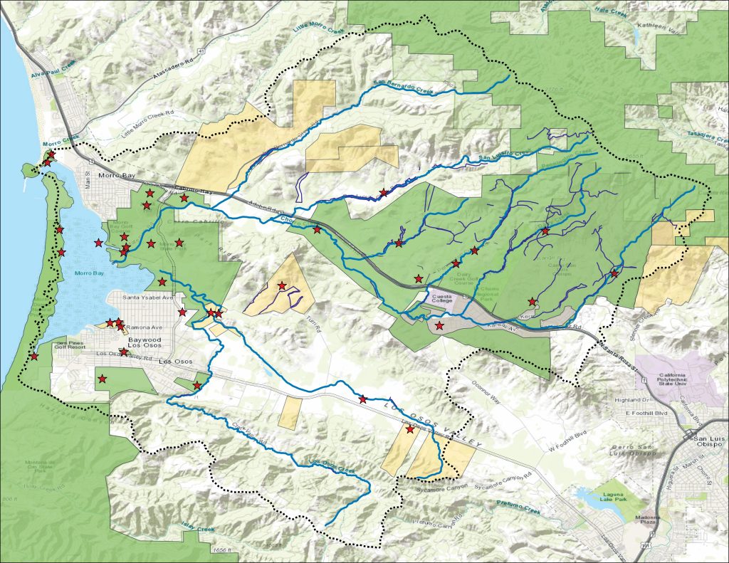
Morro Bay Watershed Habitat Protected, Enhanced, and Restored
Training the Next Generation of Land Stewards
The Morro Bay estuary and the lands that surround it host a wide variety of habitats that require active management to protect and restore. Grasslands within the Morro Bay watershed are dominated by invasive species like brome grasses, thistles, and mustard that threaten native plant biodiversity and increase wildfire risk. Livestock grazing is an effective tool to reduce invasive species cover and fire fuel loads while improving native species habitat. Grazing can also improve soil health by adding organic matter via manure. Grasslands require active management to protect sensitive species and restore native habitat. Livestock grazing reduces the presence of invasive non-native plants and manages the fuel that can feed wildfires.
The Estuary Program recently provided funding for water infrastructure to help establish Cuesta College’s Ranch Education Program on their 75-acre grassland property. This new program supports workforce development for sustainable ranch management practices and improves grassland habitat through livestock grazing. Each semester around thirty students are trained in hands-on agricultural skills, including sustainable grazing practices and methods to maintain and monitor ranch lands. Measurements of soil and vegetation occur before and after grazing to track weed management success and soil health improvements.
The site will be grazed by cattle, goats, and sheep, as each type of animal feeds on different kinds of vegetation. Currently the site has two active pastures grazed by cattle on loan from the Cal Poly Animal Science Department to target grass species preferred by cows. The program will incorporate three additional pastures for goats and sheep in the future to target grasses, woody plants, and forbs (broad-leaved, non-woody plants). As the landscape changes with grazing, the pasture size and type of grazers will be adjusted based on habitat needs.
We are excited to support the training of future land stewards and the improvement of grassland habitat and fire resilience in the Morro Bay watershed.
Studying the Past to Create a Better Future
Understanding landscape conditions before major changes from Euro-American development provides valuable information for management and restoration efforts in our watershed. The Estuary Program has embarked on a three-year historical ecology study that involves collecting archival data such as photos, maps, and journals, compiling the information, and synthesizing it to create maps of historical habitat conditions. This effort documents information like the paths that waterways originally took, the types of plants and animals present, and Indigenous land management practices.
The project creates a habitat map of conditions in the late 18th through mid-19th centuries and a report describing landscape processes and ecological functions. Rather than attempting to recreate the past, the ultimate goal is to use this knowledge to inform sustainable land management and restoration.
Protecting Dunes Through Invasive Plant Management
Iceplant, while a common sight on our coast, is not native to the Morro Bay watershed. Originally from South Africa, this plant was introduced in California in the early 1900s to stabilize soil along roads and railroad tracks. It quickly spread and now crowds out native plants and reduces dune resilience against storms and erosion. It also threatens local rare and federally listed species like California seablite and western snowy plovers.
When the individual plants are small, iceplant will stabilize the sand. This gives iceplant an advantage over native dune plants that are adapted to frequent burial events from the shifting sands. When iceplant becomes large and established, its heavy leaves and shallow root system can destabilize the dunes and cause landslides.
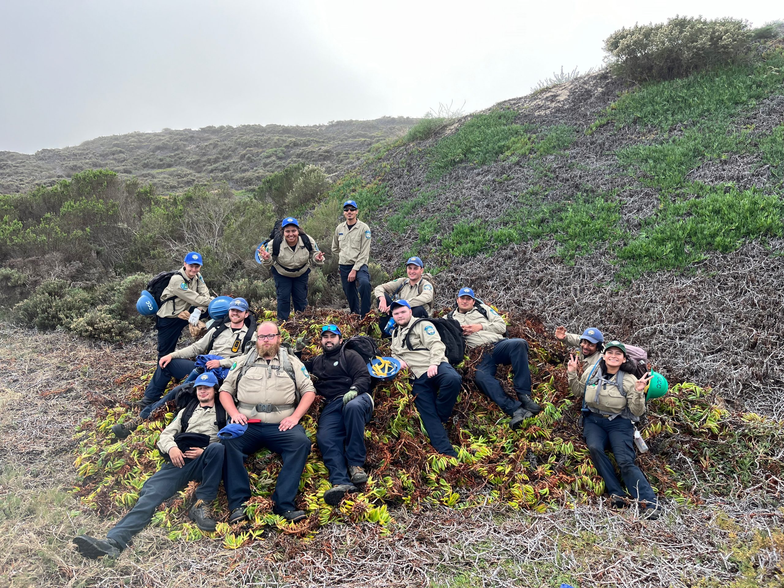
In partnership with the Coastal San Luis Resource Conservation District (CSLRCD), California State Parks, University of California at Santa Barbara, California Dune Science Network, California Conservation Corps, and others, the Estuary Program has supported iceplant removal and monitoring efforts on the dunes for the past three years. The effort improved more than 160 acres of dune habitat previously dominated by iceplant to support the return of native plants and animals.
Managing Nutrients and Sediment to Protect Habitat
In partnership with Camp San Luis Obispo (Camp SLO) and the Estuary Program, the Coastal San Luis Resource Conservation District (CSLRCD) implemented a range of projects to improve water quality across the Morro Bay watershed. Funded by the State Water Resource Control Board, these projects reduced sediment and nutrient loads through riparian fencing, cattle water infrastructure, headcut and gully repair, and irrigation system improvements in the upper Chorro, Los Osos, and Warden Creek subwatersheds.
In 2023, the CSLRCD installed bioswales along three key roads at Camp SLO. Located close to Chorro Creek in the Morro Bay Watershed, the bioswales were designed to slow down stormwater flow to capture sediment and other pollutants before they could enter Chorro Creek. This creek serves as critical habitat for sensitive species such as the threatened steelhead trout (Oncorhynchus mykiss).
In addition to the work completed on Camp SLO, the CSLRCD partnered with Cal Poly and private landowners in the Morro Bay watershed to install 20,000 linear feet of fencing and off-channel livestock water infrastructure such as tanks and troughs. This fencing restricts cattle access to the creek which reduces erosion and increases stream bank stability. The installed fence also allows for improved grazing management on the ranches through rotational grazing practices. This helps maintain ground cover to reduce runoff and improve water quality conditions.
Planning for Habitat Protection and Restoration
The Estuary Program recently completed a comprehensive, watershed-wide management approach to the health of habitats and communities of the Morro Bay watershed called the Habitat Protection & Restoration Strategy (HPRS). It was developed to guide protection, restoration, research, monitoring, education, and resiliency efforts in the Morro Bay watershed.
With our partners, we aim to improve long-term resiliency for the Morro Bay watershed habitats and interconnected coastal communities through the implementation of this strategy. To see the full plan, visit the Estuary Program website at https://www.mbnep.org/habitat-protection-restoration-strategy/
Data Notes
The watershed project map of areas protected, enhanced, and restored includes publicly and privately protected lands and areas where projects have occurred. The map includes projects by partners such as California State Parks, Coastal San Luis Resource Conservation District, The Land Conservancy of San Luis Obispo County, San Luis Obispo County, Morro Coast Audubon Society, and many others.
References
Iceplant management: https://www.mbnep.org/2022/09/23/the-fight-against-ice-plant-revealing-the-morro-bay-dunes/
Iceplant management: https://www.mbnep.org/2022/10/21/the-preservation-of-the-morro-dunes/
Iceplant management: https://www.mbnep.org/2022/12/16/the-road-to-restoration-success-the-morro-dunes/
Cuesta College sustainable ag program: https://www.mbnep.org/wp-content/uploads/2024/07/Between-the-Tides-Summer-2024.pdf
Habitat Protection & Restoration Plan: https://www.mbnep.org/wp-content/uploads/2025/04/Between-the-Tides-Spring-2025.pdf
Habitat Protection & Restoration Plan: https://www.mbnep.org/habitat-protection-restoration-strategy/