Every three years, the Estuary Program gathers available monitoring and research data to track changes in our bay and watershed. The 2026 State of the Bay report contains a section focused on extreme weather events, which is an increasingly urgent topic of discussion as deviations from established weather patterns become more common. As part of the report, we take a closer look at extreme weather events within our watershed, predictions from the latest research and modeling, and discuss efforts underway to help us adapt to a changing climate.
Record-Setting Rainfall
Local readers will likely remember the series of storms spanning December 2022 through March 2023, which caused significant flooding across the county. The peak of storm intensity was on January 9 when a weather station at Cal Poly recorded 5.35 inches of rainfall within 24 hours. This was the second highest 24-hour total recorded at this station since 1990, just below the record storm in March 1995.
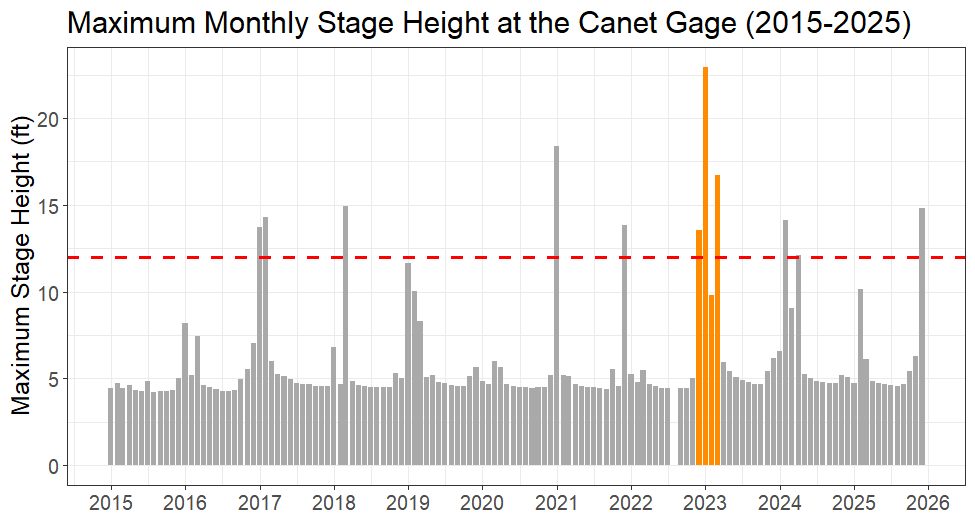
Typically, we welcome rainfall in California as a relief from persistent droughts. However, the amount of rainfall that falls over a short period of time has important impacts. Intense, flashy storms can rapidly saturate the ground and contribute to significant runoff and flooding, as seen in winter 2023. Researchers believe that these events are becoming more common due to a warming atmosphere that can hold increasingly more water. This means that it takes longer for the atmosphere to become saturated with water, leading to wider gaps between storms and longer periods of dry weather that can extend droughts. When storms finally occur, there is a lot more water to release all at one time, increasing the flood risk.
Rising Seas and Coastal Flooding
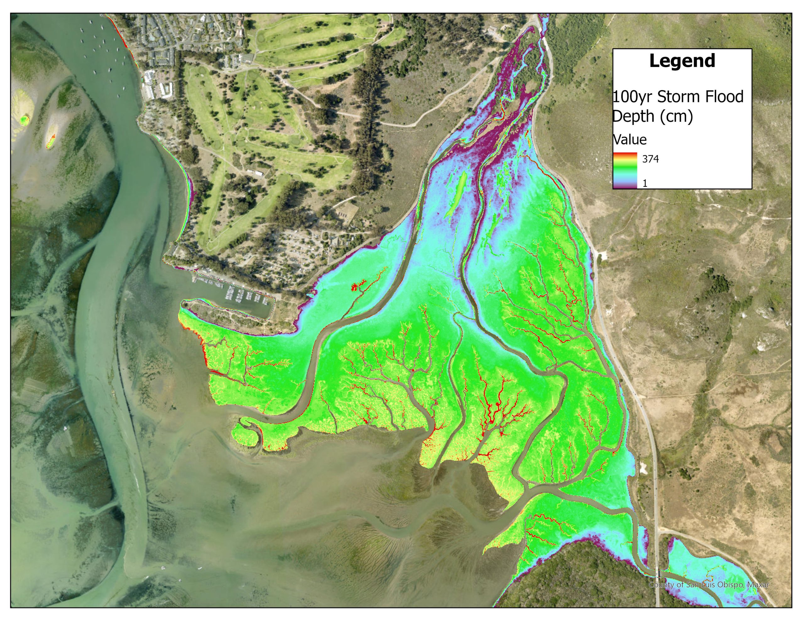
Flooding is not exclusive to freshwater creeks. Projected increases in sea level range between 0.8 feet and 3.1 feet by 2100, depending on different global emissions scenarios. Coastal infrastructure is particularly vulnerable to sea level rise, and these vulnerabilities can be amplified during storm events. The flooding observed during the 2023 storms prompted the San Luis Obispo Council of Governments (SLOCOG) to develop plans for infrastructure improvements and habitat protection that address these changing conditions.
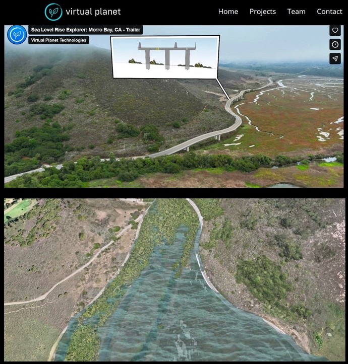
In addition to the SLOCOG project, the Coastal San Luis Resource Conservation District (CSLRCD) is exploring nature-based solutions to increase the floodplain capacity of the Chorro Flats area to reduce the risk of future flooding. The US Geological Survey (USGS) is also conducting sediment and water-level monitoring within the salt marsh to model impacts to sensitive habitats and identify strategies for protecting them from the encroaching tides.
Learning from the Past
While modelling and making projections are helpful for understanding what the future might hold, looking into the past is valuable for understanding how ecosystems have historically adapted to change. The Estuary Program has partnered with the San Francisco Estuary Institute (SFEI) to examine past landscape conditions throughout the watershed as part of a historical ecology study. SFEI creates historical habitat maps using early written accounts from the 18th century, surveys and maps from the 19th to 20th centuries, and more recent aerial imagery.
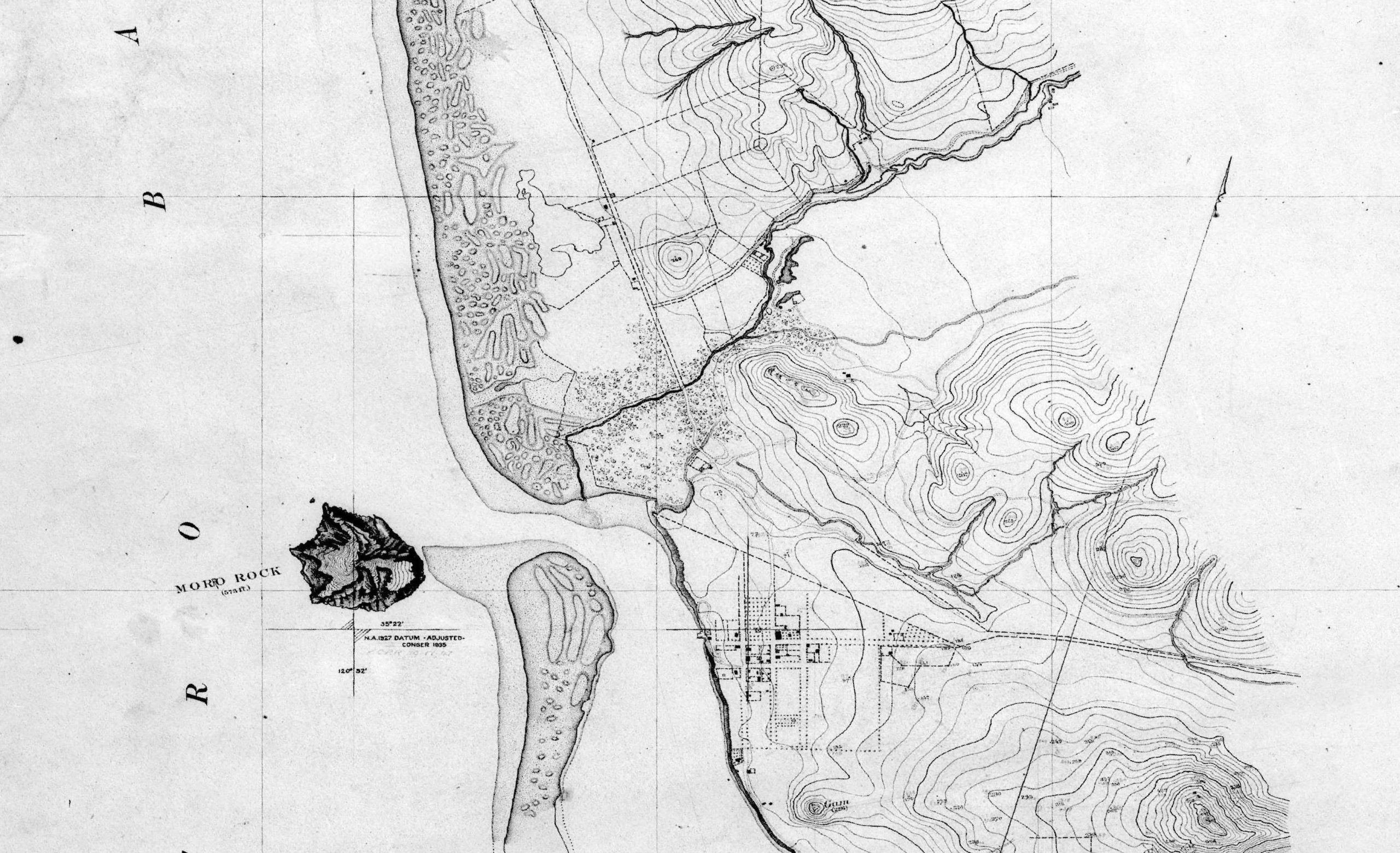
The goal of historical ecology is not to recreate the conditions of the past, but rather to learn from them so we can inform sustainable land management practices and guide future restoration projects. Against the backdrop of shifting weather patterns, rising sea levels, and infrastructure projects to keep coastal communities safe, we’re in for a great deal of change in a relatively short period of time. By contextualizing the past, we can make informed decisions that prioritize habitat preservation and protection.
To learn more about these efforts, visit the State of the Bay webpage.
References
California Ocean Protection Council. State Agency Sea Level Rise Action Plan for California. https://opc.ca.gov/wp-content/uploads/2024/02/SLR-Action-Plan-2024-Update-508.pdf
CIMIS Weather Station 52 – San Luis Obispo: https://cimis.water.ca.gov/Stations.aspx
SLO County Public Works Stage Height Gage at Canet Road: https://wr.slocountywater.org/sensor/?site_id=41&site=093f8e0b-dfde-4a45-b291-174ce07ead12&device_id=3&device=8e787d49-7f71-41b1-ae12-2559889f3431
Morro Bay Estuary Climate Resiliency Transportation Plan: https://sbbclimateplan.org/
Swain, D. L., Prein, A. F., Abatzoglou, J. T., Albano, C. M., Brunner, M., Diffenbaugh, N. S., Singh, D., Skinner, C. B., Touma, D. 2025. Hydroclimate volatility on a warming Earth. Nature Reviews: Earth & Environment. https://doi.org/10.1038/s43017-024-00624-z
Help us protect and restore the Morro Bay estuary!
- Donate to the Estuary Program today and support our work in the field, the lab, and beyond.
The Estuary Program is a 501(c)3 nonprofit. We depend on funding from grants and generous donors to continue our work. - Support us by purchasing estuary-themed gear from ESTERO. This locally owned and operated company donates 20% of proceeds from its Estuary clothing line and 100% of Estuary decal proceeds to the Estuary Program. Thank you, ESTERO!
- Purchase items from the Estuary Program’s store on Zazzle. Zazzle prints and ships your items, and the Estuary Program receives 10% of the proceeds.
- Subscribe to our seasonal newsletter: Between the Tides!
- We want to hear from you! Please take a few minutes to fill out this short survey about what type of events you’d like to see from the Estuary Program. We appreciate your input!